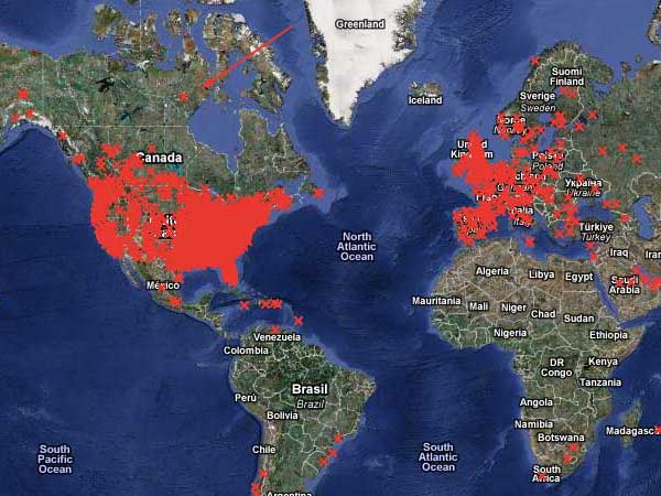
I just got finished updating the map, which necessitated figuring out how I created it in the first place. This has been on my to-do list for a long time but I was spurred on to get it done by a request from one of my wholesale customers. She sold a chart to someone who lives in Baker Lake, Nunavut, who was very anxious to have his own X on the map. Although the map really reflects the locations I’ve sold to directly, I was happy to fake up something for someone living in such an out-of-the-way place.

Have you ever heard of Nunavut? If so, you must be Canadian (or better at geography than I am). It turns out that it was only separated from the Northwest Territories (which I have heard of) in 1999, so I have a little bit of an excuse.
My main excuse for being so ignorant of geography is that I was in grade school during the cold war and what we had was military-industrial geography. Our textbook took the same approach to each country we studied: first, how many square miles it was. Then, since they realized that didn’t convey much, they would superimpose an outline of the country on an outline of whatever part of the US it was closest in size to. This was supposed to make it fun. But knowing that Remotistan is about the same size as Nebraska also doesn’t convey anything (except maybe a veiled suggestion that Remotistan sure doesn’t amount to much; countries that got compared to Rhode Island were obviously ridiculous). They would tell us what language or languages were spoken there — if it wasn’t English, there was an implication that the residents had got it wrong. We covered the form of government they had: democracy (correct) or other (incorrect). Then they would get down to a list of the products considered useful to the US. This always seemed to be grains and metals and minerals, no finished goods. The implication seemed to be that yes, the country might make precision-engineered cars or fine linens or fancy chocolates, but whatever they made, we could do it better. Sometimes they had a picture of apple-cheeked children in funny clothes, but that was about IT. I suppose we were shown where the country fit on the world map, but if you haven’t absorbed the location of country A, learning that country B is just to the east of it doesn’t help. (You can’t explain what chicken-fried steak is to someone who doesn’t know what chicken-fried chicken is.) It was really quite ugly and in a way I’m glad I didn’t learn anything. I certainly hope that geography is no longer being taught that way. But bit by bit, I’m filling in the gaps, and I’m glad to know where Nunavut is!


 I just added this beautiful little angel to the gallery. I got the picture in email a few days ago. Somehow I always drag my feet on gallery updates — I don’t know why, and I’m trying to do better. This is easily the most elaborate framing job I’ve ever seen – there are 3 mats and 2 frames. Updating the gallery reminded me that I need to finish reorganizing the images on the site — there are really too many to be in one directory. I’ve already moved the gallery images to their own place (and missed updating one of the gallery pages, now fixed).